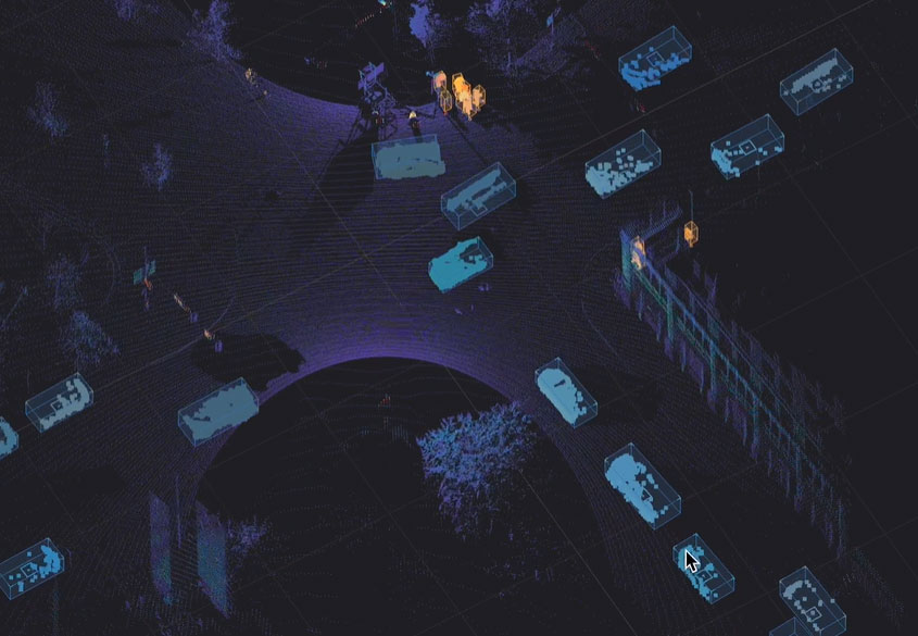
Lidar’s role in smart transportation infrastructure for a safer, connected future with ADAS and V2X

The rise of ADAS to improve road user safety
Vehicles are rapidly evolving with Advanced Driver Assistance Systems (ADAS) aimed at reducing fatalities and injuries. These technologies include collision warnings, automatic emergency braking, and lane-keeping assist systems, paving the way for autonomous driving. The EU targets a 50% reduction in road fatalities by 2030 and near-zero by 2050 through widespread adoption of ADAS. The Partnership for Analytics and Research in Traffic Safety reports substantial ADAS penetration in new vehicles, with 10 out of 14 key features exceeding 50% market penetration and 5 over 90%.
To maximize the safety benefits of ADAS-equipped vehicles, modernizing road safety infrastructure is essential. While ADAS technologies can reduce certain types of crashes, their effectiveness can be improved with smarter infrastructure that provides richer, real-time data about road users and environmental conditions. This requires an upgrade beyond basic traffic signals and static signage towards intelligent infrastructure capable of communicating directly with vehicles, pedestrians, and cyclists. The progress in infrastructure communication is linked to V2X technology. The V2X market was valued at USD 3.59 billion in 2024 and is expected to reach USD 42.69 billion by 2031, indicating that V2X may play a significant role in future infrastructure plans.
Introducing V2X: A new era of connected mobility and smart infrastructure
V2X communication technology is rapidly expanding and transforming road safety efforts, fueled by connected car advancements, a stronger focus on traffic safety, and supportive government and regulatory initiatives. At its core, V2X enables connected vehicles to communicate wirelessly with:
- Other vehicles (V2V)
- Infrastructure (V2I – also known as smart infrastructure)
- Pedestrians (V2P)
- The broader network (V2N)
Real-time data exchange through V2X communication enhances road safety by improving situational awareness and preventing injuries. Originally focused on V2V collision avoidance, V2X now includes infrastructure intelligence, with Roadside Units (RSUs) broadcasting signal phase and timing, and connected vehicles using this data for better decision-making.
The FCC’s unanimous ruling on cellular-vehicle-to-everything (C-V2X) on November 21, 2024, aims to improve vehicle and infrastructure communication, reducing crashes, improving traffic flow, supporting autonomous vehicles, and modernizing road infrastructure. These regulations are expected to boost innovation and economic growth, promoting connected transportation technologies like 3D digital lidar-powered solutions.
Ouster BlueCity: Intelligent infrastructure for a connected future
Ouster leads in modernizing road infrastructure, V2X, and intelligent transportation. Ouster BlueCity combines 3D digital lidar with AI perception software and data analytics to create a real-time 3D traffic twin of intersections or roads, detecting and tracking multimodal users in all conditions for improved safety.
The system automates cloud-based data collection to monitor road events for vehicles, pedestrians, and cyclists, offering detailed analytics for quick safety interventions and long-term planning. This cost-efficient solution integrates seamlessly with V2X communications, aiding traffic operators and city planners in managing intersections and public corridors effectively while preparing for ADAS-equipped vehicles.
How Ouster BlueCity powers V2X for enhanced safety

Ouster BlueCity’s real-time 3D digital traffic twin surpasses traditional sensors by offering precise detection, classification, and tracking of all road users. This spatial awareness helps identify safety threats to vulnerable users, providing reliable safety messages for V2X applications.
Here’s how Ouster BlueCity works for a V2X integration:
- Detection and tracking for accurate safety messages: Following a fast and simple install of Ouster BlueCity at an intersection or road, transportation agencies and municipalities can accurately detect and track the precise geolocation, speed, and trajectory of different types of vehicles, pedestrians, and cyclists.
- Standardized safety message generation: Using accurate data from Ouster BlueCity, the system converts object metadata into standardized SAE J2735 Basic Safety Messages (BSM) for vehicles and Personal Safety Messages (PSM) over 5G for pedestrians and cyclists. Furthermore, Ouster BlueCity supports the more advanced SAE J3224 (SDSM), enabling the combination of information for all road users into a single, more comprehensive message that provides richer contextual awareness to connected vehicles.
- Broadcasting safety information to connected road users: A RSU receives the safety messages from Ouster BlueCity and broadcasts them to connected vehicles and VRUs equipped with OBUs This allows drivers and other road users to receive real-time alerts about potential hazards, such as a pedestrian entering a crosswalk outside of the designated time or a cyclist approaching rapidly, even if they are not directly visible to the driver, significantly enhancing VRU safety.
- Seamless integration with RSUs: Ouster BlueCity features technology-agnostic V2X integration capabilities designed for efficient plug-and-play compatibility with various RSU vendors. By strictly adhering to SAE standards, there is no need for custom API development, thereby simplifying deployment and ensuring interoperability.
Key Benefits of Ouster BlueCity for V2X road safety:
High-resolution 3D data is essential for precise near detection and tracking. Unlike cameras that provide 2D views, Ouster BlueCity generates accurate 3D bounding boxes, delineating object boundaries with high precision. This capability is vital for safety-critical applications, offering detailed information on the type of road user and accurate geolocation with minimal latency.
Accurate detection of safety events relies on precise identification of object boundaries, known as bounding boxes. Many camera-based systems produce 2D bounding boxes that may not accurately reflect the actual edges of objects, leading to potential false positives where background elements are incorrectly identified as part of the object.
Conversely, as depicted in the right image, a 3D lidar system produces bounding boxes that precisely conform to the true contours of objects. This accuracy significantly reduces false positives, thereby improving the reliability of the detection algorithm.
In conclusion, 3D spatial awareness is crucial for precise detection and substantial reduction in false positives, ensuring reliable V2X detection and communication.
Seyond’s SIMPL formula for success in the US

Seyond reports it has achieved “a major operational milestone” by deploying its end-to-end Lidar-based ITS platform to enable traffic signal actuation in Georgia, US.
By combining the Falcon Lidar sensor with its NEMA TS2-rated SIMPL (Seyond ITS Management Platform) at Peachtree Corners’ Technology Parkway, Seyond says it delivered reliable vehicle presence detection to the traffic controller, demonstrating full stop bar actuation with independently validated results.

SIMPL combines Lidar detection hardware, perception software and traffic system integration. This offers highway agencies a resilient, infrastructure-ready deployment model that Seyond says simplifies operations, improves reliability and enhances scalability.
Notably, SIMPL is traffic-controller-agnostic. In this deployment, SIMPL’s perception software transmitted vehicle presence data to the traffic signal controller using the Serial Data Link Communications (SDLC) protocol, ensuring precise, standards-compliant communication without reliance on proprietary interfaces.
This flexibility enables seamless integration into a wide variety of intersection environments and controller ecosystems, the company says.
The SIMPL platform delivers 3D multimodal detection with unmatched accuracy and resilience. Agencies can start with basic detection and scale into advanced operations, analytics and safety capabilities through SIMPL’s modular software licensing model.
The project supports the City of Peachtree Corners’ broader Smart City strategy, in partnership with Curiosity Lab, to address operational inefficiencies along Technology Parkway.
The goal is to explore innovative applications of Lidar for multimodal detection, including vehicles, pedestrians and vulnerable road users.
“Our work with Seyond and their SIMPL system demonstrates how Lidar-based detection can optimise traffic operations, not just collect data,” said Brian Johnson, city manager of Peachtree Corners.
Seyond – based in Sunnyvale, California – is collaborating with the Georgia’s Department of Transportation to expand the application across multiple intersections along State Route 141, Peachtree Parkway. The broader pilot will enable real-time roadside data collection, creating a scalable model for future-ready traffic management. This initiative will be highlighted at the 2025 ITS World Congress in Atlanta, Georgia, in August.
Meanwhile, Seyond has announced a strategic partnership with Twincrest Technologies to accelerate deployment of SIMPL across the states of Texas, Louisiana and Mississippi. Twincrest will serve as a channel partner and certified integrator for SIMPL, offering consulting, deployment and support services tailored to local and regional agency needs throughout the Gulf South region.